

ST. LOUIS — Heavy rain fell early Monday morning with one to two inches of rain fairly common. Since last Thursday, some areas have recorded more than four inches of rainfall. STL-Lambert has had over 8 inches of rainfall for April, this is well above the average rainfall for the month of just over 4 1/2".
Clearing will continue from the west to the east into the evening. With a soggy ground, a mainly clear sky and light winds Monday night into Tuesday morning, areas of fog may develop. The most likely area for fog is in the river valley and low spots.
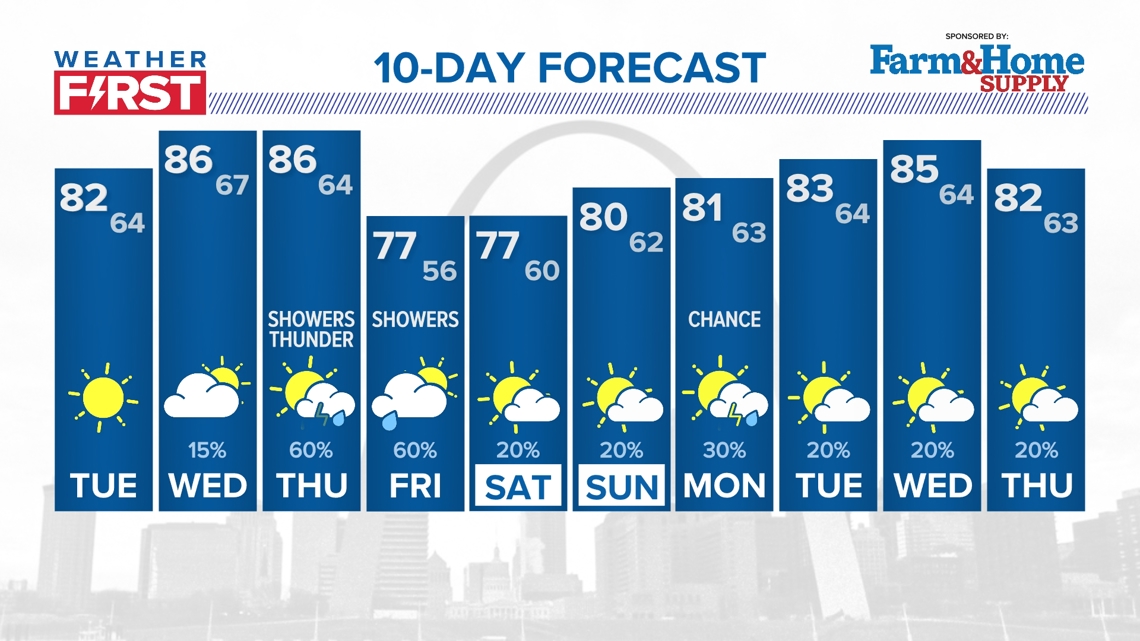
Dry weather returns Tuesday with temperatures heating up, back into the lower 80s. There is a slim chance for a shower or thunderstorms during the pre dawn hours Wednesday. Otherwise, Wednesday and Thursday will be the warmest days of the week with highs climbing into the mid and upper 80s. Wednesday, we're forecasting 88, but the record high is 90 set back in 1936.
By late-week, more showers and thunderstorms are expected with the best chance of rain on Thursday and Thursday night into Friday morning. Right now, the severe weather chances seem limited, but check back for any updates. The weekend looks mostly dry with highs in the 70s and near 80 on Sunday.

ST. LOUIS METRO FORECAST
Tonight: Mostly clear, lows in the low 50s with some areas of fog possible, especially in the valley locations.
Tuesday: Areas of morning fog, then sunny, much warmer...highs in the low 80s. An overnight shower, possible some thunder especially I-70 northward.
Wednesday: Partly sunny and toasty. Highs in the mid to upper 80s.
Thursday: Clouds increase, breezy. Shower and thunderstorm chances increase by the late afternoon and evening. Highs in the middle 80s.
Friday: Showers likely early. Highs in the middle 70s.
Saturday: Partly sunny. Highs in the middle 70s. 20% rain chance.
Sunday: Partly sunny, 20% chance of showers or storms possible. Highs near 80.
Monday: Partly sunny with scattered showers or storms. Highs near 80.
Tuesday: Partly sunny, slim shower chance. Highs in the 80s.
Wednesday: Partly sunny, slim chance for rain...highs in the mid 80s.
Latest High-Resolution Model Output:
Download the free 5 On Your Side app to get the latest watches and warnings and track conditions live with our interactive radar. Use the links below to download now.
The Weather First Team will use "Storm Alert" to refer to life-threatening or major-impact weather conditions in our region. "Weather Alert" refers to nuisance or disruptive weather and is indicated by orange icons and bars in our weather graphics on TV and online.
5 On Your Side news app
iPhone | Google Play
To watch 5 On Your Side broadcasts or reports 24/7, 5 On Your Side is always streaming on 5+. Download for free on Roku or Amazon Fire TV.

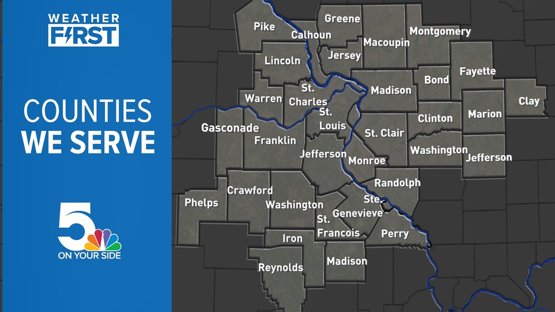
In Missouri, we serve these counties: Crawford County, Franklin County, Gasconade County, Iron County, Jefferson County, Lincoln County, Madison County, Perry County, Phelps County, Pike County, Reynolds County, St. Charles County, St. Francois County, St. Louis City, St. Louis County, Ste. Genevieve County, Warren County, and Washington County.
In Illinois, we serve Bond County, Calhoun County, Clay County, Clinton County, Fayette County, Greene County, Jefferson County, Jersey County, Macoupin County, Madison County, Marion County, Monroe County, Montgomery County, Randolph County, St. Clair County, and Washington County.


Listen to Weather First updates with your radio on 93.7 The Bull or 103.3 KLOU.